Archives Record
Images
Metadata
Catalog Number |
1999.26.1 |
Object Name |
Map |
Title |
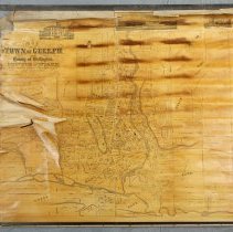
Map, Town of Guelph, 1875 |
Date |
1875 |
Year Range from |
1875 |
Year Range to |
1875 |
Description |
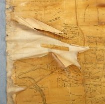
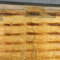
Map of the Town of Guelph, dated to 1875. The map depicts wards, street lamps, railroads, streets, watermains, properties and the names of landowner's outside the city, and some topography. The map is composed of paper with a fabric backing. There are two wooden dowels at each end. Along the top of the map are 3 illustrations of Town Hall, the Market House and the Courthouse and jail. The map is titled as "Map of the Town of Guelph in County of Wellington Province of Ontario from Actual Surveys and original Plans by T.W. Cooper, C.E & PLS." |
Notes |
Mapmaking is an ancient, global, and subjective practice. Maps can help us to understand land relationships over time. It is important to understand why a specific map was made, whose interests it reflected, and how it was intended to be used. These understandings are shaped by knowledge of the land from diverse perspectives, past, present, and future. Historic Context: Early Indigenous navigational maps of the place we now call Canada were drawn on impermanent materials, accompanied by verbal descriptions and committed to memory. Landmarks were accentuated to aid travellers and scale was often measured by time (such as, a day's journey). In about 1502, European mapmakers depicted the east coast of Newfoundland as an island in the North Atlantic. World maps skewed the size and shape of continents and used colour to symbolize colonial powers. The first surveyors measured and marked plots of land - taken, traded, granted, or sold - often naming the landholders on the map. Today, the science and practice of mapmaking documents the topography of the landscape in fine detail, through aerial photography, sensors, satellites, and global positioning/information systems (GPS/GIS). |
People |
Allan, David (Sr.) (1808-1895) Armstrong, J.B. Arnold Arvis Bell, Matthew Billings Biscoe, F. Buckland Chadwick, Frederick Jasper Chadwick, John Craven Clarke, William Fletcher (Rev.) Clarke, William (Dr.) Coffee, Dennis Cooper, T.W. Cox, Thos. Cunningham, J.J. Davis, A.R. Day, William Denroache Dyson Elliot, George Elliott, George Emslie Ferguson Fraser, Thomas Freeman, George Gordon, John Gow, Peter Graham Grange, George John (Sheriff) Grange, George John (Sheriff) Guthrie, Donald Harrison, Edward Hatch, Henry Hearn, William Higinbotham, Nathaniel Hogg, John Hood, George Hood, William Horsman, John Howitt, John Hubbard Inglis, John Jackson, John Kennedy, David Kingsmill, John Juchereau Kirkland Lemon, Andrew Macdonald Macdonald, Alexander Marryat Martin, Edward R. Massie, James McDonald, Evan McDonald, John McDonald, Lachlan McTague Mickle Mitchell, John Moon, Hugh Murphy, James Oliver Orr, Mary Palmer, Reverend Arthur Patterson, George Peterson, Henry W. Pipe, John Richardson, Robert Ritchie, Andrew Robinson, Thomas Ryan Scott Sharpe, C. Smith, Thomas Stevenson, William Stewart, Edward Maclean Sturdy, F. Tearney Thompson Torrance, Reverend Robert Wallace, Douglas Watt, James Webster Wells, Arthur White, Robert |
Search Terms |
Allan's Bridge Allan's Dam Allan's Distillery Allan's Mill Alma Block Birmingham Quarry Catholic Rectory City Hall Court House Drill Hall Exhibition Park Exhibition Park - Crystal Palace Fraser and Henderson Goldie's Mill Gow's Mill Grand Trunk Railway Grand Trunk Railway Bridge Grand Trunk Railway Station Great Western Railway Guelph General Hospital Guelph Grammar School Guelph Jail Ker Cavan Loretto Academy Market Square Oil Refinery Pipe's Mill Priory Roman Catholic Church Glebe St. Bartholomew's Church St. George's Church St. George's Square St. Stanislaus School Stevenson's Nursery Town of Guelph Union Cemetery Victoria Place Views |
Subjects |
MAPS |
Collection |
Artifacts |