Archives Record
Images
Additional Images [11]
Metadata
Catalog Number |
1981X.233.1 |
Object Name |
Map |
Title |
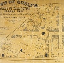
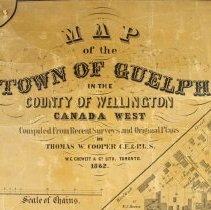
Map, Town of Guelph, 1862 |
Date |
1862 |
Year Range from |
1862 |
Year Range to |
1862 |
Description |
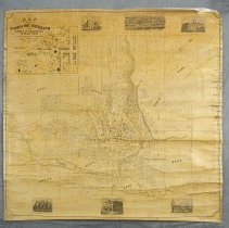
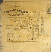
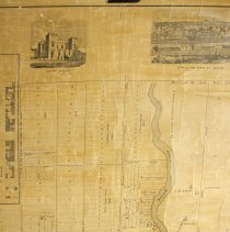
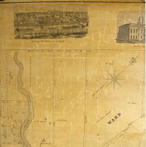
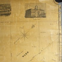
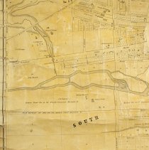
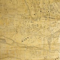
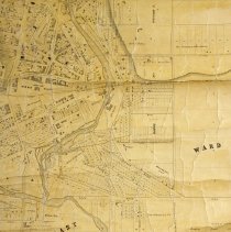
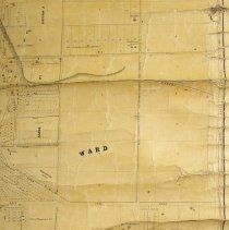
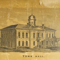
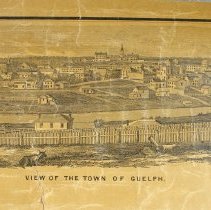
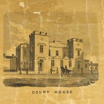
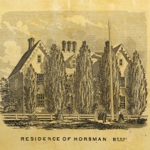
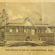
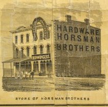
Map of the Town of Guelph, created by Thomas W. Cooper, and printed by W.C. Chewett and Company Lithographers, dated 1862. There are three illustrations along the top of the map that depict the court house, a view of the Town of Guelph, and town hall. There are three more illustrations along the bottom of the map depicting the residence of Horsman, the Horsman Brothers store, and the residence of Nathaniel Higinbotham. The map also includes a close-up of the intersection at Wyndham Street and Quebec Street circling St. Georges church. The map is labelled at the top left as, "Map of the Town of Guelph in the County of Wellington Canada west, Compiled from Recent Survey and Original Plans by Thomas W. Cooper, C.E. & P.L.S., W.C. Chewett & Co. Lith. Toronto 1862." |
Notes |
Mapmaking is an ancient, global, and subjective practice. Maps can help us to understand land relationships over time. It is important to understand why a specific map was made, whose interests it reflected, and how it was intended to be used. These understandings are shaped by knowledge of the land from diverse perspectives, past, present, and future. Historical Context: Early Indigenous navigational maps of the place we now call Canada were drawn on impermanent materials, accompanied by verbal descriptions and committed to memory. Landmarks were accentuated to aid travellers and scale was often measured by time (such as, a day's journey). In about 1502, European mapmakers depicted the east coast of Newfoundland as an island in the North Atlantic. World maps skewed the size and shape of continents and used colour to symbolize colonial powers. The first surveyors measured and marked plots of land - taken, traded, granted, or sold - often naming the landholders on the map. Today, the science and practice of mapmaking documents the topography of the landscape in fine detail, through aerial photography, sensors, satellites, and global positioning/information systems (GPS/GIS). |
People |
Allan, David (Sr.) (1808-1895) Alling, Robert (Dr.) Baker, Alfred A. Barber, George Brown, W.J. Clarke, (Dr.) Clarke, William (Dr.) Cooper, T.W. Corbett, C. Cormack Cox, Thos. Croft, Nathaniel Crowe, William Cunningham, J.T. Day, William Devlin, Felix Dunbar, R. Elliott, G. Emsley, P. Ferguson, Richard Freeman, George Gow, Peter Grange, George John (Sheriff) Greet, R. Hewitt, W. Higinbotham, Nathaniel (Col.) Hogg, John Hood, George Hood, William Horning, Charles Howitt, John Jackson, A.M. Jackson, John Joffrey Jones, R. Kay, Henry Keller Kingsmill, John Juchereau Lewis, John Marcon, F. Marcon, F. Martin, Edward R. Martin, S. McCrae, John (not poet) McDonald, Evan Millar Mitchell, John Moran, P. Mulholland, H. Newton, F. Nichols, J. O'Neil, J. Oliver, Mrs. Orr, Mary Palmer, Reverend Arthur Patham, G.P. Peterson, Henry W. Platt, J. Presant, J. Prest, N. Richardson, Robert Rutherford, Robert Ryan, M. Sandilands, Thomas Savage, D. Scott, Robert Stewart, Edward Maclean Stewart, G.M. Stewart, J.B. Sunley, N. Sunley, R. Thomson, Robert Torrance, Reverend Robert Tovell, James. A. Underhill, W. Watson, J. Wells, Arthur White, Robert Wilson, William Wood, J. A. |
Search Terms |
Aerial View of Guelph Alma Block Bank of Montreal Baptist Church British Hotel Brown (W.J.) and Company Grocers Calver's Nursery City Hall Congregational Church Court House Day's Block Fraser and Henderson Galt and Guelph Railway Galt and Guelph Railway Station Goldie's Mill Great Western Hotel Guelph Grammar School Guelph Jail Holliday Brothers Brewery Horsman Hardware Horsman Hill Horsman House Knox Presbyterian Church Market Square Norfolk Street United Church Ontario Bank Post Office Registry Office Riverview Riverview Roman Catholic Church Glebe St. Andrew's Church St. Andrew's Church Glebe St. George's Church Glebe Stevenson's Nursery Stewart and Thompson Thorp's Hotel Todd (George) and Sons Tinsmiths Town of Guelph Union Cemetery Views Wellington Place |
Subjects |
MAPS |
Collection |
Archives |