Archives Record
Images
Metadata
Catalog Number |
2013.39.4 |
Object Name |
Survey, Land |
Title |
Land Survey, Howitt Street, 1895 |
Date |
24 April 1895 |
Year Range from |
1895 |
Year Range to |
1895 |
Description |
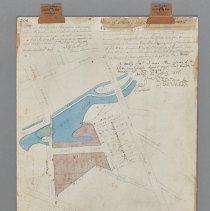
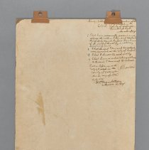
Land survey of the Howitt Street lots in Guelph, dated to 1895. The survey covers the area bordered by Crawford, Surrey, Neeve and Bridge Streets. The survey depicts the Speed River (in blue) and the Howitt lots in pink. There is a section of lots between Margaret and Neeve Streets that are labelled as belonging to the John A. MacDonald Survey. The survey is mounted to a board and along the top there are two brown Cello Clips. At the very top left corner is "306" handwritten in black - the survey number. The bridge at Huskisson and Crawford Streets (now Wyndham Street S), is labelled as "Fool Bridge." In the top left corner it reads: "I hereby certify that this plan accurately shows the manner in which the land included therin has been surveyed and sub-divided by me and that the said plan is prepared in accordance with the provisions of The Registry Act, 1893, Alfred Howitt Ontario Land Surveyor Dated April 18, 1895" In the top right corner it reads: "Plan of Survey made by Alfred Howitt. Being a subdivision of that portion of John A. MacDonald survey composed of the Lot No. 6 in the block laid for Samuel Crawford by Frances Kerr P.L.S. being part of broken front of Lot No. 3 in Division F in the Township of Guelph, also Lots No. 161 and 174 on Crawford Street, and Lots No. 88 and 173 on Margaret Street according to Registered Plan No. 113. I certify that I am the owner of the above mentioned lands and this survey is made at my request. Dated 24th April, 1895, Jane Howitt by her attorney Chas. E. Howitt witness K. Maclean" In the bottom left it reads: "Note: The dotted lines CD, DA, AB and south east side of the River Speed indicate the position of Park Lot No. 6 in John A Macdonald's survey; GAHF and FHB show lots 174 and 161 on Crawford St., and DIJ and DEC show position of old lots 88 and 173 on Margaret Street" The handwriting in black ink on the reverse of the survey reads, In the top right corner is: "County of Wellington [section covered by Cello Clip] Maclean of the City of Guelph in the County of Wellington Barrister at Law, make oath and say: 1. That I was personally present and did see the within Plan and Duplicate thereof duly signed by Jane Howitt one of the parties thereto by her attorney, Charles E. Howitt. 2. That the said Plan and Duplicate were executed at the City of Guelph. 3. That I know the said property 4. That I am a subscribing witness to the said Plan and duplicate M.C. Higginbotham Dy. Regr. Sworn before me at the City of Guelph in the County of Wellington this 24 day of April, A.D. 1895, K. Maclean" In bottom left corner is: "Plan No. 306 Entered and registered this 4th day of May A.D. 1895 as No. 306 M.C. Higinbottham Dy. Regr" |
Notes |
Mapmaking is an ancient, global, and subjective practice. Maps can help us to understand land relationships over time. It is important to understand why a specific map was made, whose interests it reflected, and how it was intended to be used. These understandings are shaped by knowledge of the land from diverse perspectives, past, present, and future. Historical Context: Early Indigenous navigational maps of the place we now call Canada were drawn on impermanent materials, accompanied by verbal descriptions and committed to memory. Landmarks were accentuated to aid travellers and scale was often measured by time (such as, a day's journey). In about 1502, European mapmakers depicted the east coast of Newfoundland as an island in the North Atlantic. World maps skewed the size and shape of continents and used colour to symbolize colonial powers. The first surveyors measured and marked plots of land - taken, traded, granted, or sold - often naming the landholders on the map. Today, the science and practice of mapmaking documents the topography of the landscape in fine detail, through aerial photography, sensors, satellites, and global positioning/information systems (GPS/GIS). Historical Context - John A. MacDonald John A. McDonald worked as a surveyor for the Canada Company circa 1835. His original survey of the area was used by Alfred Howitt in 1895 as the basis for this updated survey of a subdivision of Lot No. 6 on the east side of today's Wyndham Street South. The site was first patented by the Crown in approximately 1832. The first recorded deed for the site was issued to Samuel Crawford who purchased the land from the Canada Company. The land was sold to various people several times between 1832 and 1876 when it was purchased by Jane Howitt, for whom this updated survey was prepared. Jane sold the land to E. Howitt in 1900. By 1902, portions of this land became the location of the Guelph Carpet Mill Company Limited. Research Resources: 1. Barrett, Laura. "Phase One Environmental Site Assessment 68-76 Wyndham Street South, Guelph, Ontario." EXP Services Inc. 30 May 2019. https://guelph.ca/wp-content/uploads/76-Wyndham-Phase-One-Environmental-Assessment.pdf. |
People |
Higinbotham, M.C. Howitt, Alfred Howitt, Charles E. Howitt, Jane McLean, K. |
Search Terms |
Bridge Street Crawford Street Cross Street Howitt Street Huskisson Street Huskisson Street Bridge Margaret Street Neeve Street Richardson Street |
Subjects |
LAND USE STREET PLAN |
Dimensions |
34 cm w x 48.5 cm l |
Collection |
Archives |