Archives Record
Images


Additional Images [1]

Metadata
Catalog Number |
1984.4.6 |
Object Name |
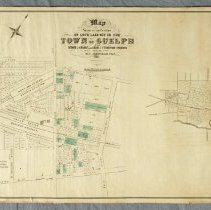
Map |
Title |
Map, Town of Guelph, 1855 |
Date |
1855 |
Year Range from |
1855 |
Year Range to |
1855 |
Description |
Map of the lots owned by George J. Grange and Adam J. Fergusson, surveyed by M.C. Schofield, printed by Maclear and Company, dated to 1855. Multi-lot subdivision plan located on either side of Edinburgh Road, abutting the Galt and Guelph, and Grand Trunk Railway Stations. There are pencil markings on the map, crossing out blocks of plots and labelling some plots with a "D." Some plots have been coloured in with green ink. The map features the residence of G.J. Grange. Map is printed in black ink on paper with a fabric backing and a pink ribbon to tie. At the bottom left of the map, "Note. The Lots on east side of Edinburgh Street are the survey of A.J. Fergusson Esqr, and those on West side are the Survey of George J. Grange Esqr." |
Notes |
Mapmaking is an ancient, global, and subjective practice. Maps can help us to understand land relationships over time. It is important to understand why a specific map was made, whose interests it reflected, and how it was intended to be used. These understandings are shaped by knowledge of the land from diverse perspectives, past, present, and future. Historical Context: Early Indigenous navigational maps of the place we now call Canada were drawn on impermanent materials, accompanied by verbal descriptions and committed to memory. Landmarks were accentuated to aid travellers and scale was often measured by time (such as, a day's journey). In about 1502, European mapmakers depicted the east coast of Newfoundland as an island in the North Atlantic. World maps skewed the size and shape of continents and used colour to symbolize colonial powers. The first surveyors measured and marked plots of land - taken, traded, granted, or sold - often naming the landholders on the map. Today, the science and practice of mapmaking documents the topography of the landscape in fine detail, through aerial photography, sensors, satellites, and global positioning/information systems (GPS/GIS). |
People |
Fergusson, Adam Johnston (A.J.) Grange, George John (Sheriff) Schofield, M.C. |
Search Terms |
Alma Street Berlin Road Cathcart Place Crimea Street Edinburgh Road Elora Street Fergus Street Fleet Street Galt and Guelph Railway Galt and Guelph Railway Station Galt Street Grand Trunk Railway Grand Trunk Railway Station Inkerman Street Lucan Street Market Street Omar Street Paisley Road Preston Street Raglan Street Southhampton Street St. Arnaud Street Sultan Street Sydenham Street Waterloo Avenue Yorkshire Street |
Subjects |
MAPS RAILWAY |
Collection |
Archives |