Archives Record
Images
Metadata
Catalog Number |
1981.276.3 |
Object Name |
Map |
Title |
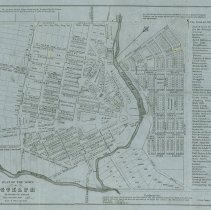
Map, Town of Guelph, 1847 |
Date |
1847 |
Year Range from |
1847 |
Year Range to |
1847 |
Description |
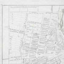
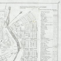
Map of the Town of Guelph by Donald MacDonald, dated to 1847. The map depicts lot numbers, street names, and town pumps which are marked with a black dot. A table on the right of the map features the population, number of houses, commercial establishments and industries for 1843,1846 and 1847. The type at the top left of the map reads, "Note - The portions between Palmer Street and the Eramosa Road & between Grange Street and Budd Street are the property of John McDonald Esq." |
Notes |
Mapmaking is an ancient, global, and subjective practice. Maps can help us to understand land relationships over time. It is important to understand why a specific map was made, whose interests it reflected, and how it was intended to be used. These understandings are shaped by knowledge of the land from diverse perspectives, past, present, and future. Historical Context: Early Indigenous navigational maps of the place we now call Canada were drawn on impermanent materials, accompanied by verbal descriptions and committed to memory. Landmarks were accentuated to aid travellers and scale was often measured by time (such as, a day's journey). In about 1502, European mapmakers depicted the east coast of Newfoundland as an island in the North Atlantic. World maps skewed the size and shape of continents and used colour to symbolize colonial powers. The first surveyors measured and marked plots of land - taken, traded, granted, or sold - often naming the landholders on the map. Today, the science and practice of mapmaking documents the topography of the landscape in fine detail, through aerial photography, sensors, satellites, and global positioning/information systems (GPS/GIS). Biographical Context - John A. MacDonald John A. MacDonald began buying land across Ontario in the 1840s and early 1850s because there was a predicted rise in property demand as railway lines in the area expanded. MacDonald bought 50 acres of low-lying and relatively swampy land in what would become St. Patrick's Ward in 1854. These swampy, low-lying areas of land were difficult to sell. Macdonald's agent only successfully sold 40 lots between 1855 and 1868. This map was likely produced for MacDonald's land agent to advertise the amenities available in Guelph and encourage future buyers. The table along the left edge of the map highlights Guelph's amenities as an incentive for newcomers to the town. Likewise, the note mentioning the map's "proforma design," suggest that a portion of the town did not currently exist as it was depicted in the map, but rather, was to encourage people to see future possibilities for the town's growth. Research Resources: 1. J. K. Johnson and P. B. Waite, "MacDonald, Sir John Alexander," in Dictionary of Canadian Biography, vol. 12, University of Toronto/Université Laval, 1990, accessed August 18, 2022, http://www.biographi.ca/en/bio/macdonald_john_alexander_12E.html. |
People |
MacDonald, Donald |
Search Terms |
Albert Street Arthur Street Bedford Street Bristol Street Budd Street Cambridge Street Cardigan Street Duke Street Durham Street Eramosa Road George Street Grange Street Grant Street Huskisson Street Kent Street Liverpool Street London Road Market Street Market Street Nelson Crescent Northumberland Street Norwich Street Oxford Street Paisley Street Princess Street Queen Street Suffolk Street Surrey Street Thurtell Street Wellington Street Woolwich Street Yarmouth Street Yorkshire Street |
Subjects |
COMMERCIAL INDUSTRY & TRADE MAPS RESTAURANTS LAND RECORDS |
Collection |
Archives |