Archives Record
Images
Metadata
Catalogue Number |
2006.22.2 |
Object Name |
Map |
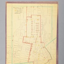
Title |
Map, Royal Tour, Traffic Detour, 1959 |
Date |
1959 |
Year Range from |
1959 |
Year Range to |
1959 |
Description |
Map depicting the detour for traffic during the Royal Tour in Guelph, dated to 1959. The map depicts where traffic was rerouted while the Royal Tour was on. The map is bordered by Edinburgh Road, Delhi Street, Speedvale and Waterloo Avenues. There are three different colours of pencil crayon on the map. The green illusrates roads that are open to traffic, the red marks what streets were restricted and the red arrows are where barricades were placed. The yellow dots indicate duty locations. Titled "Appendix B Traffic Detour". |
Notes |
Mapmaking is an ancient, global, and subjective practice. Maps can help us to understand land relationships over time. It is important to understand why a specific map was made, whose interests it reflected, and how it was intended to be used. These understandings are shaped by knowledge of the land from diverse perspectives, past, present, and future. Historical Context: Early Indigenous navigational maps of the place we now call Canada were drawn on impermanent materials, accompanied by verbal descriptions and committed to memory. Landmarks were accentuated to aid travellers and scale was often measured by time (such as, a day's journey). In about 1502, European mapmakers depicted the east coast of Newfoundland as an island in the North Atlantic. World maps skewed the size and shape of continents and used colour to symbolize colonial powers. The first surveyors measured and marked plots of land - taken, traded, granted, or sold - often naming the landholders on the map. Today, the science and practice of mapmaking documents the topography of the landscape in fine detail, through aerial photography, sensors, satellites, and global positioning/information systems (GPS/GIS). |
Search Terms |
Allan's Bridge Arthur Street Baker Street Canadian National Railway Station Carden Street Cardigan Street Cavell Avenue City Hall Clarence Street Clarke Street Cork Street Division Street Dublin Street Earl Street Edinburgh Road Eramosa Road Exhibition Park Exhibition Street Farquhar Street Glasgow Street Glenwood Avenue Gordon Street Grand Trunk Railway Station Kathleen Street Kent Street Kirkland Street Liverpool Street London Road Macdonell Street McTague Street Mont Street Norfolk Street Northumberland Street Norwich Street Oxford Street Paisley Street Park Avenue Powell Street Priory Square Quebec Street Royal Visits Speedvale Avenue St. Andrews Street St. George's Square Suffolk Street Summit Crescent Surrey Street Tiffany Street Tipperary Place Torrance Crescent Trafalgar Square Verney Street Westmount Road Wilson Street Woolwich Street Wyndham Street Yorkshire Street |
Subjects |
SPECIAL EVENTS - ROYALTY |
Collection |
Archives |