Archives Record
Images
Additional Images [5]
Metadata
Catalog Number |
1981X.232.1 |
Object Name |
Map |
Title |
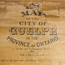
Map, Guelph, W. Hill Tout, 1892 |
Date |
April 1892 |
Year Range from |
1892 |
Year Range to |
1892 |
Description |
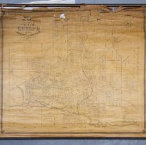
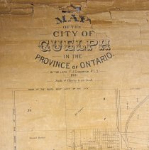
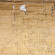
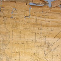
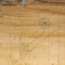
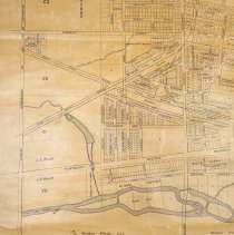
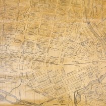
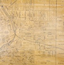
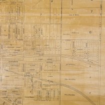
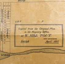
Map, of Guelph originally complied by Frederick Jasper Chadwick in 1891, copied and printed by W. Hill Tout in 1892, The map depicts lot numbers, lot divisions, street names, surveys, railways, the Speed and Eramosa Rivers, the Mill Pond, city limits, and includes the names of owners with large land holdings. This map was compiled by F.S. Chadwick from the surveys of multiple surveyors, one of which was John MacDonald (of Goderich). MacDonald was the principal surveyor for the Canada Company, and his survey is noted multiple times along the right of the map. The map is composed on paper affixed to a fabric backing, and nailed to a black wooden slat at the top and a black wooden rod nailed at the bottom. The lower right corner reads "Copied from the Original plan in the Registry Office by W. Hill Tout City Engineer, Guelph April 1892." |
Notes |
Mapmaking is an ancient, global, and subjective practice. Maps can help us to understand land relationships over time. It is important to understand why a specific map was made, whose interests it reflected, and how it was intended to be used. These understandings are shaped by knowledge of the land from diverse perspectives, past, present, and future. Historic Context: Early Indigenous navigational maps of the place we now call Canada were drawn on impermanent materials, accompanied by verbal descriptions and committed to memory. Landmarks were accentuated to aid travellers and scale was often measured by time (such as, a day's journey). In about 1502, European mapmakers depicted the east coast of Newfoundland as an island in the North Atlantic. World maps skewed the size and shape of continents and used colour to symbolize colonial powers. The first surveyors measured and marked plots of land - taken, traded, granted, or sold - often naming the landholders on the map. Today, the science and practice of mapmaking documents the topography of the landscape in fine detail, through aerial photography, sensors, satellites, and global positioning/information systems (GPS/GIS). Historic Context - Canada Company The Canada Company was chartered in 1825 as a land and colonization company based in London, England. In 1826, the company purchased from the British Crown about 2.5 million acres of land on the shores of Lake Huron in Upper Canada (modern-day Ontario). The Canada Company remained in operation until its last parcel of land was sold in the 1950s. Novelist and colonial promoter John Galt (1779-1839) was the first superintendent of the Canada Company. Galt arrived in Upper Canada in 1826 and founded Guelph on 23 April 1827. He was recalled to Britain in 1829 after conflicting with the Company's directors. Guelph was a planned town. Galt's original layout, with streets radiating from a single focal point, is still visible in Guelph's downtown core. Galt adopted the concept of a "planned town" in advance of general settlement in order to stimulate sales of agricultural land. He named Guelph after Britain's royal family, the Hanoverians, who were descended from the Guelfs. Guelph was first incorporated as a village in 1851, and then as a town in 1856. Biographical Context - John MacDonald John MacDonald (1794-1873) worked as the principal surveyor for the Canada Company and was nicknamed "Stout Mac" for his strength. He also superintended the entire laying out of the Huron Tract by the Canada Company. He became the sheriff of the Huron district in 1845, and later of Huron County. He was a resident of Goderich at the time of his death. 1. Armstrong, Frederick H. "McDonald, Donald (d. 1879)." Dictionary of Canadian Biography, vol. 10. University of Toronto/Université Laval. Accessed August 23, 2022. http://www.biographi.ca/en/bio/mcdonald_donald_1879_10E.html. 2. "The Late Sherriff MacDonald." Huron Signal, (Goderich, ON), Aug. 6, 1873. https://www.canadiana.ca/view/oocihm.N_00197_18730806/2. 3. McLeod, Donald W. "The Final Days of Nicholas Melady Jr. as Witnessed by William Dickson." The Champlain Society. University of Toronto. Accessed, August 22, 2022. https://champlainsociety.utpjournals.press/findings-trouvailles/the-last-days-of-nicholas-melady-jr. Biographical Context - Frederick Jasper Chadwick Frederick Jasper Chadwick was the second son of John Craven Chadwick (Senior). He was born on 19 November 1838, and died on 20 June 1891. He was the Captain of the Wellingon Milita, a Provincial Land Surveyor, and the owner of the Guelph Herald newspaper for several years. He was a member of the County Council in the County of Wellington and served on the Town Council of Guelph (of which he was Mayor in 1877) multiple times. He married on 3 September 1861 to Elisabeth (died 3 August 1894), who was the daughter of Edward Michael Stewert (in Holy Orders of Guelph and afterwards of Clooney, County Derry, Ireland) and Jane Renwick Jeffery. Research Resources: Edward Marion Chadwick, The Chadwicks of Guelph and Toronto and Their Cousins, (1845), 59. https://www.forgottenbooks.com/en/download/TheChadwicksofGuelphandTorontoandTheirCousins_10652782.pdf |
People |
Alderson, George Barber, Samuel Wilson Billings, Sarah Buckland Chadwick Chadwick, Frederick Jasper Clark, R. Coffee, Dennis Davidson, Charles Denroche, William S. Dunbar Dyson Fergusson, Adam Johnston (A.J.) Goldie, James Gow Grange, George John (Sheriff) Guthrie, D. Harrison Hart Harvey Hattin, John H. Hearn Heffernan Higinbotham, Nathaniel (Col.) Hood, George Hood, James Howitt, C.E. Hubbard Hughes Jackson Kingsmill, John Juchereau Kirkland Knowles Macdonald, A.H. Macdonald, John Marcon McCartney McCrae, Mrs. McKenzie McTague, C. McTague, P. Meagher, Thomas Mitchell Murphy, Catherine Murphy, Ellen Murton, Mrs. Harry Neeve Oliver Owen Oxnard, G.A. Palmer, Reverend Arthur Patterson Prior, Charles Stewart Thompson Thorp, J. Tiffany Tout, W. Hill Wood |
Search Terms |
Albert Street Allan's Mill Alma Street Arnold Street Arthur Street Bay Street Bedford Street Berlin Road Birmingham Street Bridge Street Bristol Street Budd Street Cambridge Street Canadian Pacific Railway Canadian Pacific Railway Bridge Canadian Pacific Railway Station Cardigan Street Charles Street Church of Our Lady City of Guelph City of Guelph - Water Works Clarence Street Clarke Street Clinton Street Cork Street Crimea Street Day Street Derry Street Douglas Street Douglas Street Dublin Street Duke Street Dundas Road Durham Street Edinburgh Road Edwin Street Elgin Street Elora Street Eramosa Road Essex Street Exhibition Park Fergus Street Fleet Street Foster Avenue Fountain Street Galt and Guelph Railway Galt and Guelph Railway Station Galt Street George Street Gladwin Street Glasgow Street Glasgow Street Grand Trunk Railway Grand Trunk Railway Grand Trunk Railway Bridge Grand Trunk Railway Station Grand Trunk Railway Station Grange Street Grant Street Great Western Railway Guelph Collegiate Vocational Institute (GCVI) Guelph Grammar School Guelph Jail Homewood Health Centre Hood Street Hooper Street Huskisson Street Inkerman Street James Street John Street Kerr Street King Street Liverpool Street London Road Macdonell Street Manchester Street Marcon Street Margaret Street Market Square Market Street Mary Street Mercer Street Merion Street Metcalfe Street Mill Street Mitchell Street Mount Street Neeve Street Nelson Crescent Norfolk Street Northumberland Street Norwich Street Nottingham Street Omar Street Oxford Street Paisley Street Pearl Street Perth Street Pipe Street Powell Street Preston Street Princes Street Priory Priory Street Quebec Street Queen Street Raglan Street Richardson Street Roman Catholic Church Glebe Short Street Silver Creek Road Southhampton Street Spring Street St. Andrew's Church Glebe St. Arnaud Street St. Bartholomew's Church St. George's Church St. George's Church Glebe St. George's Square Stevenson's Nursery Suffolk Street Sultan Street Surrey Street Sydenham Street Thorp Street Thurtell Street Tiffany Street Toronto Street Victoria Place Waterloo Avenue Wellington Street Woolwich Street Wyndham Street Yarmouth Street York Road Yorkshire Street Palmer Street Lemon Street |
Subjects |
MAPS |
Collection |
Archives |