Archives Record
Images
Metadata
Catalog Number |
1973.41.1.2 |
Object Name |
Map |
Title |
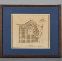
Map, Town of Guelph, 1827 |
Date |
1827 |
Year Range from |
1827 |
Year Range to |
1827 |
Description |
Map of Guelph, reduced by F.Cattlin and engraved by J. and C. Walker, dated to 1827. The map depicts the Speed River at the top and right, with St. Patrick's in the centre. The map features the saw mill, an office, St. George's church, Guelph burial ground, Market grounds, and Woolwich, Eramosa, York, Gordon, Market, Huskisson, Grant, and Brown Streets. Map is printed in brown, green, black and beige ink on paper. The entire map is encased in a wood and glass frame with a blue matt. At the upper-right corner it is labelled: "Plan of the Town of Guelf Upper Canada, Founded by the Canada Company 1827." Printed at the bottom left, "Reduced by F.Cattlin, and at the bottom right; "Engraved by J&C Walker." |
Notes |
Mapmaking is an ancient, global, and subjective practice. Maps can help us to understand land relationships over time. It is important to understand why a specific map was made, whose interests it reflected, and how it was intended to be used. These understandings are shaped by knowledge of the land from diverse perspectives, past, present, and future. Historical Context: Early Indigenous navigational maps of the place we now call Canada were drawn on impermanent materials, accompanied by verbal descriptions and committed to memory. Landmarks were accentuated to aid travellers and scale was often measured by time (such as, a day's journey). In about 1502, European mapmakers depicted the east coast of Newfoundland as an island in the North Atlantic. World maps skewed the size and shape of continents and used colour to symbolize colonial powers. The first surveyors measured and marked plots of land - taken, traded, granted, or sold - often naming the landholders on the map. Today, the science and practice of mapmaking documents the topography of the landscape in fine detail, through aerial photography, sensors, satellites, and global positioning/information systems (GPS/GIS). Historic Context - Canada Company The Canada Company was chartered in 1825 as a land and colonization company based in London, England. In 1826, the company purchased from the British Crown about 2.5 million acres of land on the shores of Lake Huron in Upper Canada (modern-day Ontario). The Canada Company remained in operation until its last parcel of land was sold in the 1950s. Novelist and colonial promoter John Galt (1779-1839) was the first superintendent of the Canada Company. Galt arrived in Upper Canada in 1826 and founded Guelph on 23 April 1827. He was recalled to Britain in 1829 after conflicting with the Company's directors. Guelph was a planned town. Galt's original layout, with streets radiating from a single focal point, is still visible in Guelph's downtown core. Galt adopted the concept of a "planned town" in advance of general settlement in order to stimulate sales of agricultural land. He named Guelph after Britain's royal family, the Hanoverians, who were descended from the Guelfs. Guelph was first incorporated as a village in 1851, and then as a town in 1856. |
Search Terms |
Canada Company Clarence Street Eramosa River Gordon Street Huskisson Street Market Square Speed River St. Patrick's Catholic Church Union Cemetery Waterloo Avenue Woolwich Street |
Subjects |
HISTORY-LOCAL MAPS STREET PLAN URBAN SETTLEMENT |
Collection |
Artifacts |