Archives Record
Images
Additional Images [3]
Metadata
Catalogue Number |
1981X.228.1 |
Object Name |
Map |
Title |
Map, Guelph, circa 1875 |
Date |
circa 1875 |
Year Range from |
1870 |
Year Range to |
1880 |
Description |
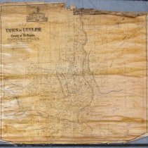
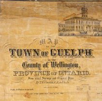
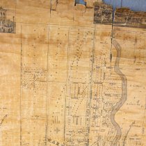
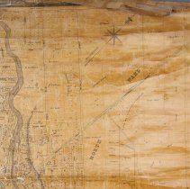
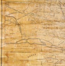
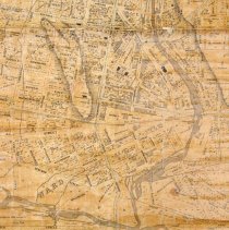
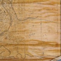
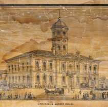
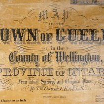
Map of Guelph compiled by T.W Cooper, dated circa 1875. The map depicts streets, some topography, the Speed and Eramosa Rivers, land owners, lot numbers, street lamps, watertanks, churches illustrated by a black building footprint, and some buildings illustrated by a grey building footprint. The map features three illustrations at the top of, City Hall, the Town of Guelph, and one of the Court House and Jail. This map was compiled by T.W Cooper from the surveys and plans of multiple surveyors, one of which was John MacDonald (of Goderich). MacDonald was the principal surveyor for the Canada Company, and his survey is noted multiple times along the right of the map. The map is printed in black ink on paper with a fabric backing, and nailed to two wooden slats at the top and a black wooden slat at the bottom. The top left corner of the map reads, "Map of the Town of Guelph in the County of Wellington, Province of Ontario from actual Surveys and Original Plans by T.W. Cooper, C.E and P.L. S. Copp Clark & Company Lithographers, Toronto." |
Notes |
Mapmaking is an ancient, global, and subjective practice. Maps can help us to understand land relationships over time. It is important to understand why a specific map was made, whose interests it reflected, and how it was intended to be used. These understandings are shaped by knowledge of the land from diverse perspectives, past, present, and future. Historical Context: Early Indigenous navigational maps of the place we now call Canada were drawn on impermanent materials, accompanied by verbal descriptions and committed to memory. Landmarks were accentuated to aid travellers and scale was often measured by time (such as, a day's journey). In about 1502, European mapmakers depicted the east coast of Newfoundland as an island in the North Atlantic. World maps skewed the size and shape of continents and used colour to symbolize colonial powers. The first surveyors measured and marked plots of land - taken, traded, granted, or sold - often naming the landholders on the map. Today, the science and practice of mapmaking documents the topography of the landscape in fine detail, through aerial photography, sensors, satellites, and global positioning/information systems (GPS/GIS). Historic Context - Canada Company The Canada Company was chartered in 1825 as a land and colonization company based in London, England. In 1826, the company purchased from the British Crown about 2.5 million acres of land on the shores of Lake Huron in Upper Canada (modern-day Ontario). The Canada Company remained in operation until its last parcel of land was sold in the 1950s. Novelist and colonial promoter John Galt (1779-1839) was the first superintendent of the Canada Company. Galt arrived in Upper Canada in 1826 and founded Guelph on 23 April 1827. He was recalled to Britain in 1829 after conflicting with the Company's directors. Guelph was a planned town. Galt's original layout, with streets radiating from a single focal point, is still visible in Guelph's downtown core. Galt adopted the concept of a "planned town" in advance of general settlement in order to stimulate sales of agricultural land. He named Guelph after Britain's royal family, the Hanoverians, who were descended from the Guelfs. Guelph was first incorporated as a village in 1851, and then as a town in 1856. Historical Context - John MacDonald John MacDonald (1794-1873) worked as the principal surveyor for the Canada Company and was nicknamed "Stout Mac" for his strength. He also superintended the entire laying out of the Huron Tract by the Canada Company. He became the sheriff of the Huron district in 1845, and later of Huron County. He was a resident of Goderich at the time of his death. Research Resources: 1. Armstrong, Frederick H. "McDonald, Donald (d. 1879)." Dictionary of Canadian Biography, vol. 10. University of Toronto/Université Laval. Accessed August 23, 2022. http://www.biographi.ca/en/bio/mcdonald_donald_1879_10E.html. 2. "The Late Sherriff MacDonald." Huron Signal, (Goderich, ON), Aug. 6, 1873. https://www.canadiana.ca/view/oocihm.N_00197_18730806/2. 3. McLeod, Donald W. "The Final Days of Nicholas Melady Jr. as Witnessed by William Dickson." The Champlain Society. University of Toronto. Accessed, August 22, 2022. https://champlainsociety.utpjournals.press/findings-trouvailles/the-last-days-of-nicholas-melady-jr. |
People |
Allan, David (Sr.) (1808-1895) Armstrong, J.B. Arnold Arvis Bell, Matthew Billings Biscoe, F. Buckland Chadwick, Frederick Jasper Chadwick, John Craven Clarke, William Fletcher (Rev.) Clarke, William (Dr.) Coffee, Dennis Cooper, T.W. Cox, Thos. Cunningham, J.J. Davis, A.R. Day, William Denroache Dyson Elliot, George Elliott, George Emslie Ferguson Fraser, Thomas Freeman, George Gordon, John Gow, Peter Graham Grange, George John (Sheriff) Grange, George John (Sheriff) Guthrie, Donald Harrison, Edward Hatch, Henry Hearn, William Higinbotham, Nathaniel (Col.) Hogg, John Hood, George Hood, William Horsman, John Howitt, John Hubbard Inglis, John Jackson, John Kennedy, David Kingsmill, John Juchereau Kirkland Lemon, Andrew Macdonald Macdonald, Alexander Marryat Martin, Edward R. Massie, James McDonald, Evan McDonald, John McDonald, Lachlan McTague Mickle Mitchell, John Moon, Hugh Murphy, James Oliver Orr, Mary Palmer, Reverend Arthur Patterson, George Peterson, Henry W. Pipe, John Richardson, Robert Ritchie, Andrew Robinson, Thomas Ryan Scott Sharpe, C. Smith, Thomas Stevenson, William Stewart, Edward Maclean Sturdy, F. Tearney Thompson Torrance, Reverend Robert Wallace, Douglas Watt, James Webster Wells, Arthur White, Robert |
Search Terms |
Allan's Bridge Allan's Dam Allan's Distillery Allan's Mill Alma Block Birmingham Quarry Catholic Rectory City Hall Court House Drill Hall Exhibition Park Exhibition Park - Crystal Palace Fraser and Henderson Goldie's Mill Gow's Mill Grand Trunk Railway Grand Trunk Railway Bridge Grand Trunk Railway Station Great Western Railway Guelph General Hospital Guelph Grammar School Guelph Jail Guelph Jail Ker Cavan Loretto Academy Market Square Oil Refinery Pipe's Mill Priory Roman Catholic Church Glebe St. Bartholomew's Church St. George's Church St. George's Square St. Stanislaus School Stevenson's Nursery Town of Guelph Union Cemetery Victoria Place Views |
Subjects |
LAND RECORDS MAPS |
Collection |
Archives |