Please help us improve our records by providing feedback.
Collection of Personal Information
Personal information provided on this form is collected and used for the purposes of responding to feedback, updating our records (e.g. making suggested edits) and communicating with you about related matters.
Personal information, as defined by Section 2 of the Municipal Freedom of Information and Protection of Privacy Act (MFIPPA), is collected under the authority of the Municipal Act, 2001, and in accordance with the provisions of MFIPPA.
If you have questions about the collection, use and disclosure of this personal information, please contact the City’s Information and Access Coordinator by phone at 519-822-1260 extension 2349 or email privacy@guelph.ca.
Images
1 of 1977
Image Request Form
Please fill out this form to request an image and click the Submit Request button when done. Museum staff will contact you to confirm the details of your request.
Image Price List
1-2 digital images without watermark $10.00 each
3 or more digital images without watermark $7.00 each
Processing fee (per order not image) $2.50
13% HST charged on all Canadian orders
Collection of Personal Information
Personal information provided on this form is collected and used for the purposes of processing image requests, administering image reproduction agreements and communicating with you about related matters.
Personal information, as defined by Section 2 of the Municipal Freedom of Information and Protection of Privacy Act (MFIPPA), is collected under the authority of the Municipal Act, 2001, and in accordance with the provisions of MFIPPA.
If you have questions about the collection, use and disclosure of this personal information, please contact the City’s Information and Access Coordinator by phone at 519-822-1260 extension 2349 or email privacy@guelph.ca.
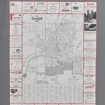
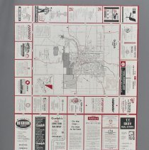
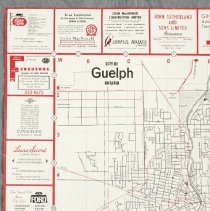
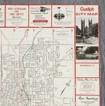
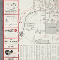
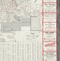
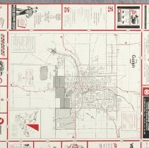
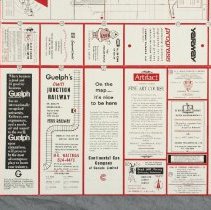
Double-sided map of the City of Guelph produced by the Canadian Cartographic Company with artwork by Canadian Coldtype Company, for the Guelph Chamber of Commerce, dated to 1970.
The front of the map depicts a detailed street plan with railways and major roadways marked in red. A street index appears at the bottom of the map. The map is bordered by advertisements in a red grid for local businesses. Text and artwork are printed in black and red ink on white paper. The back of the map depicts a smaller and less detailed map of the city and indicates points of interest. The back is also is bordered by advertisements for local businesses divided by a red grid. The map folds into a rectangular with a black and white photograph of Church of Our Lady, the McCrae House and Memorial Gardens on front.
Notes
Mapmaking is an ancient, global, and subjective practice. Maps can help us to understand land relationships over time. It is important to understand why a specific map was made, whose interests it reflected, and how it was intended to be used. These understandings are shaped by knowledge of the land from diverse perspectives, past, present, and future.
Historical Context:
Early Indigenous navigational maps of the place we now call Canada were drawn on impermanent materials, accompanied by verbal descriptions and committed to memory. Landmarks were accentuated to aid travellers and scale was often measured by time (such as, a day's journey).
In about 1502, European mapmakers depicted the east coast of Newfoundland as an island in the North Atlantic. World maps skewed the size and shape of continents and used colour to symbolize colonial powers. The first surveyors measured and marked plots of land - taken, traded, granted, or sold - often naming the landholders on the map.
Today, the science and practice of mapmaking documents the topography of the landscape in fine detail, through aerial photography, sensors, satellites, and global positioning/information systems (GPS/GIS).