Archives Record
Images
Metadata
Catalog Number |
2013.39.31 |
Object Name |
Survey, Land |
Title |
Land survey, Dunkirk Avenue Subdivision, 1948 |
Date |
23 June 1948 |
Year Range from |
1948 |
Year Range to |
1948 |
Description |
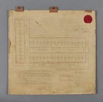
Land survey of the Dunkirk Avenue Subdivision, Guelph, dated to 23 June 1948. The plan depicts subdivided lots at the intersection of, and on either side of, Cassino and Dunkirk Avenues. The plan features 32 lots on Dunkirk and 12 on Cassino. The plan lots are bordered in red. In the top right corner is a red seal stamped with the mark of the County of Wellington. Across the top there are three Cello Clip hooks that allow the plan to hang. In the upper left corner is "408" the number of the plan. At the top of the plan it reads: "Plan of survey of Subdivision of parts of lots 7 and 8 in the second range of Division F formerly in the Township, now in the City of Guelph, and Lot 24. Registered Plan No. 128, City of Guelph, County of Wellinton Scale." Top right of the plan reads "I hereby certify that this plan has been duly entered and filed in the Registry of Office for the Registry Division of the South and Centre Ridings of the County of Wellington at 10 o'clock AM on the 23rd day of June A.D. 1948 as plan No. 408 for the City of Guelph J.B. Morrison Registrar" The bottom left of plan reads: "I, Shirley King, an Ontario Land Surveyor, certify that, (A) I was present at and did personally superintend the survey represented by this plan (B) This plan accurately shows the manner in which lands (edged in red) have been surveyed and subdivided by me; (C) Every angle of the exterior boundary of the plan is defined in the survey thereof by a monument, and a monument is placed at one angle of each street intersection shown on the plan; (D) I have indicated on the plan the position and form of each of the monuments (E) The monuments conform in all respects to requirements of section 13 of the Surveys Act; (F) The survey was made by me between the 6th day of May 1946 and the 5th day of July 1946 (G) The survey has been accurately made in accordance with all the provisions of the Surveys Act and the Registry Act relating thereto. Dated at Brantford, Ont. the 4th day of June, 1948. Shirley King Ontario Land Surveyor" The bottom right reads: "I hereby certify that this plan represents a true copy of the field notes in connection with the survey thereof. I hereby certify that this is the original plan. Shirley King Ontario Land Surveyor" Stamped just below this is: "Approved under section 26 of The Planning Act, 1948 Dana Porter Minister of Planning & Development" |
Notes |
Mapmaking is an ancient, global, and subjective practice. Maps can help us to understand land relationships over time. It is important to understand why a specific map was made, whose interests it reflected, and how it was intended to be used. These understandings are shaped by knowledge of the land from diverse perspectives, past, present, and future. Historical Context: Early Indigenous navigational maps of the place we now call Canada were drawn on impermanent materials, accompanied by verbal descriptions and committed to memory. Landmarks were accentuated to aid travellers and scale was often measured by time (such as, a day's journey). In about 1502, European mapmakers depicted the east coast of Newfoundland as an island in the North Atlantic. World maps skewed the size and shape of continents and used colour to symbolize colonial powers. The first surveyors measured and marked plots of land - taken, traded, granted, or sold - often naming the landholders on the map. Today, the science and practice of mapmaking documents the topography of the landscape in fine detail, through aerial photography, sensors, satellites, and global positioning/information systems (GPS/GIS). |
Search Terms |
Cassino Avenue City of Guelph - Department of Planning and Development Dunkirk Avenue Lane Street |
Subjects |
LAND RECORDS |
Dimensions |
52 cm w x 52.5 cm l |
Collection |
Archives |