Archives Record
Images
Metadata
Catalog Number |
1974.14.1 |
Object Name |
Map |
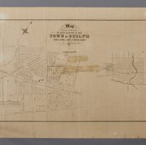
Title |
Map, Town of Guelph, 1855 |
Date |
1855 |
Year Range from |
1855 |
Year Range to |
1855 |
Description |
Map of the lots owned by George J. Grange and Adam J. Fergusson, surveyed by M.C. Schofield, published by Maclear and Company, and dated to 1855. The map depicts the multi-lot subdivision plan located on either side of Edinburgh Road, abutting the Galt and Guelph, and the Grand Trunk Railway Stations. There are pencil markings on the map, encircling a block of lots between Sydenham Street and Berlin Street, on either side of Fergus Street, and marking many lots with an 'X,' a checkmark, or both. The right of the map includes an inset of the whole Town of Guelph. The map is printed in black ink on paper. The map is titled across the top as "Map Shewing the Position of Lots Laid Out in the Town of Guelph for George J. Grange and Adam J. Fergusson Esquires By M.C. Schofield, P.L.S. 1855." The left of the map has a note that reads "The Lots on east side of Edinburgh Street are the Survey of A.J. Fergusson Esqr, and those on West side are the Survey of George J. Grange Esqr." |
People |
Adam J. Fergusson Grange, George John (Sheriff) Schofield, M.C. |
Search Terms |
Alma Street Berlin Road Cathcart Place Crimea Street Edinburgh Road Elora Street Fergus Street Fleet Street Galt and Guelph Railway Galt and Guelph Railway Station Galt Street Grand Trunk Railway Grand Trunk Railway Station Inkerman Street Lucan Street Market Street Omar Street Paisley Road Preston Street Raglan Street Southhampton Street St. Arnaud Street Sultan Street Sydenham Street Waterloo Avenue Yorkshire Street |
Subjects |
MAPS RAILWAY |
Collection |
Archives |