Archives Record
Images
Metadata
Catalog Number |
1981X.230.1 |
Object Name |
Map |
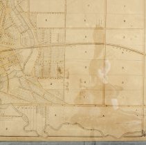
Title |
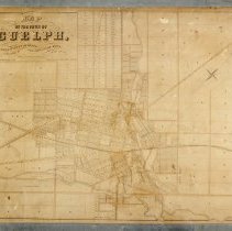
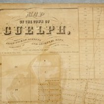
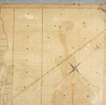
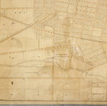
Map, Town of Guelph, 1855 |
Date |
1855 |
Year Range from |
1855 |
Year Range to |
1855 |
Description |
Map of the Town of Guelph published by J. Smith and drawn by Frederick Jasper Chadwick in May 1855. The map was printed in black ink onto paper with a fabric back by John Ellis of Toronto. The map depicts divisions, wards, lot numbers, street names, railroad tracks, train stations, and the Speed River. There is a decorative black border. Note: there are 2 of each of the following streets, Mary, George, and Alma. |
Notes |
Mapmaking is an ancient, global, and subjective practice. Maps can help us to understand land relationships over time. It is important to understand why a specific map was made, whose interests it reflected, and how it was intended to be used. These understandings are shaped by knowledge of the land from diverse perspectives, past, present, and future. Historical Context: Early Indigenous navigational maps of the place we now call Canada were drawn on impermanent materials, accompanied by verbal descriptions and committed to memory. Landmarks were accentuated to aid travellers and scale was often measured by time (such as, a day's journey). In about 1502, European mapmakers depicted the east coast of Newfoundland as an island in the North Atlantic. World maps skewed the size and shape of continents and used colour to symbolize colonial powers. The first surveyors measured and marked plots of land - taken, traded, granted, or sold - often naming the landholders on the map. Today, the science and practice of mapmaking documents the topography of the landscape in fine detail, through aerial photography, sensors, satellites, and global positioning/information systems (GPS/GIS). Biographical Context - Frederick Jasper Chadwick Frederick Jasper Chadwick was the second son of John Craven Chadwick (Senior). He was born on 19 November 1838, and died on 20 June 1891. He was the Captain of the Wellingon Milita, a Provincial Land Surveyor, and the owner of the Guelph Herald newspaper for several years. He was a member of the County Council in the County of Wellington and served on the Town Council of Guelph (of which he was Mayor in 1877) multiple times. He married on 3 September 1861 to Elisabeth (died 3 August 1894), who was the daughter of Edward Michael Stewert (in Holy Orders of Guelph and afterwards of Clooney, County Derry, Ireland) and Jane Renwick Jeffery. Research Resources: Edward Marion Chadwick, The Chadwicks of Guelph and Toronto and Their Cousins, (1845), 59. https://www.forgottenbooks.com/en/download/TheChadwicksofGuelphandTorontoandTheirCousins_10652782.pdf |
People |
Chadwick, Frederick Jasper Freeman, George Jackson, A.M. Smith, J. Thorp, J.N. |
Search Terms |
Albert Street Alma Street Ann Street Arnold Street Arthur Street Bay Street Bedford Street Berlin Road Birmingham Street Bridge Street Bristol Street Budd Street Cambridge Street Cardigan Street Charles Street Clarence Street Clarke Street Clinton Street Cork Street Court House Crawford Street Crimea Street Cross Street Day Street Derry Street Douglas Street Douglas Street Dublin Street Duke Street Dundas Road Durham Street Edinburgh Road Edwin Street Elgin Street Elora Street Eramosa Road Essex Street Fergus Street Fleet Street Foster Avenue Fountain Street Galt and Guelph Railway Galt and Guelph Railway Station Galt Street George Street Gladwin Street Glasgow Street Glasgow Street Grand Trunk Railway Grand Trunk Railway Station Grange Street Grant Street Guelph Grammar School Guelph Jail Hood Street Hooper Street Huskisson Street Inkerman Street James Street John Street Kerr Street King Street Liverpool Street London Road Macdonell Street Manchester Street Marcon Street Margaret Street Market Street Mary Street Mercer Street Merion Street Metcalfe Street Mill Street Mitchell Street Mount Street Neeve Street Nelson Crescent Norfolk Street Northumberland Street Norwich Street Nottingham Street Omar Street Oxford Street Paisley Street Pearl Street Perth Street Pipe Street Powell Street Preston Street Princes Street Priory Street Quebec Street Queen Street Raglan Street Richardson Street Short Street Silver Creek Road Southhampton Street Spring Street St. Arnaud Street St. Bartholomew's Church St. George's Church Stevenson's Nursery Suffolk Street Sultan Street Surrey Street Sydenham Street Thorp Street Thurtell Street Tiffany Street Toronto Street Waterloo Avenue Wellington Street Woolwich Street Wyndham Street Yarmouth Street York Road Yorkshire Street |
Subjects |
MAPS NEIGHBOURHOOD ROADS STREET PLAN. |
Collection |
Archives |