Archives Record
Images
Additional Images [1]
Metadata
Catalog Number |
1981X.222.1 |
Object Name |
Map |
Title |
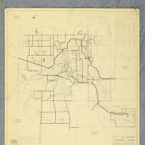
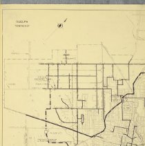
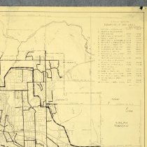
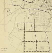
Map, Guelph Water Distribution, 1973 |
Date |
1973 |
Year Range from |
1973 |
Year Range to |
1973 |
Description |
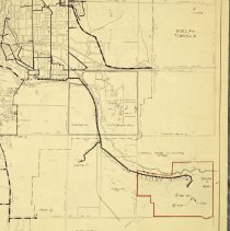
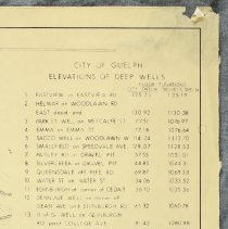
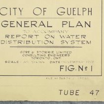
Map of Guelph's Water Distribution System, published by Gore and Storrie Limited, and dated to 1973. The map depicts the location of wells, drilled wells, water mains, proposed water mains, proposed pressure zone boundaries, and the location of proposed and existing pumping stations and reservoirs. These are differentiated by a variety of dashed lines as shown in the legend which appears in the lower left corner of the map. The map features some topography of the area, and the names of main streets. In the top right corner of the map is a list of the elevation of local deep wells. In the bottom right corner of the map are specifications for the Arkell Spring System outlined in red. The map is printed in black and red ink on paper. Written in the lower right corner of the map is "File No. 263.24-D-13238," "Tube 47." The map is labelled "City of Guelph General Plan to Accompany Report on water Distribution System, Gore & Storrie Limited, Consulting Engineers, Toronto Ont. November 1973." |
Notes |
Mapmaking is an ancient, global, and subjective practice. Maps can help us to understand land relationships over time. It is important to understand why a specific map was made, whose interests it reflected, and how it was intended to be used. These understandings are shaped by knowledge of the land from diverse perspectives, past, present, and future. Historical Context: Early Indigenous navigational maps of the place we now call Canada were drawn on impermanent materials, accompanied by verbal descriptions and committed to memory. Landmarks were accentuated to aid travellers and scale was often measured by time (such as, a day's journey). In about 1502, European mapmakers depicted the east coast of Newfoundland as an island in the North Atlantic. World maps skewed the size and shape of continents and used colour to symbolize colonial powers. The first surveyors measured and marked plots of land - taken, traded, granted, or sold - often naming the landholders on the map. Today, the science and practice of mapmaking documents the topography of the landscape in fine detail, through aerial photography, sensors, satellites, and global positioning/information systems (GPS/GIS). |
Search Terms |
Arkell Road Arkell Springs Cedar Street City of Guelph - Water Works College Avenue Dean Avenue Eastview Road Edinburgh Road Emma Street Fife Road Metcalfe Street Paisley Street Park Avenue Stone Road Water Street Woodlawn Road Yewholme Drive |
Subjects |
MAPS UTILITIES - WATER |
Collection |
Archives |