Please help us improve our records by providing feedback.
Collection of Personal Information
Personal information provided on this form is collected and used for the purposes of responding to feedback, updating our records (e.g. making suggested edits) and communicating with you about related matters.
Personal information, as defined by Section 2 of the Municipal Freedom of Information and Protection of Privacy Act (MFIPPA), is collected under the authority of the Municipal Act, 2001, and in accordance with the provisions of MFIPPA.
If you have questions about the collection, use and disclosure of this personal information, please contact the City’s Information and Access Coordinator by phone at 519-822-1260 extension 2349 or email privacy@guelph.ca.
Images
1 of 1977
Image Request Form
Please fill out this form to request an image and click the Submit Request button when done. Museum staff will contact you to confirm the details of your request.
Image Price List
1-2 digital images without watermark $10.00 each
3 or more digital images without watermark $7.00 each
Processing fee (per order not image) $2.50
13% HST charged on all Canadian orders
Collection of Personal Information
Personal information provided on this form is collected and used for the purposes of processing image requests, administering image reproduction agreements and communicating with you about related matters.
Personal information, as defined by Section 2 of the Municipal Freedom of Information and Protection of Privacy Act (MFIPPA), is collected under the authority of the Municipal Act, 2001, and in accordance with the provisions of MFIPPA.
If you have questions about the collection, use and disclosure of this personal information, please contact the City’s Information and Access Coordinator by phone at 519-822-1260 extension 2349 or email privacy@guelph.ca.
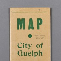
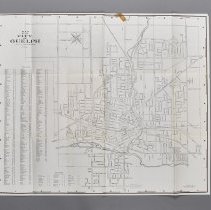
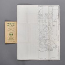
Map of Guelph drawn by William S. Haras, copyrighted by the Guelph Police Association and dated to 1958
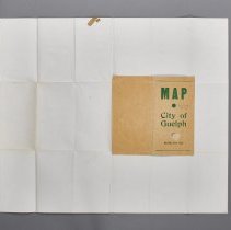
The map folds out of a brown cardstock booklet with the title and revision date printed in green ink. Inside the front cover is an advertisement for Wilf's Shell Service. The map itself is printed in black and depicts: railways, the Speed and Eramosa Rivers, and streets, with a index at left. It also includes an index to streets outside city limits at bottom left.
The map is inscribed with 3 blue ink "X"s, one on Woodlawn Road, one at the corner of Tiffany and Woolwich Streets, and one at the corner of McCrae Boulevard and Water Street. There are also pencil lines drawn on the map. One goes along Eramosa and Victoria Roads, and one along the Canadian National Railway that cuts across the Speed River to connect to Gordon Street. On the upper half of the cover is a stamp in blue ink that reads: "JOHNSON'S ENTERPRISES / 28 PEARL ST., GUELPH / PHONE TA. 2-5441."
Notes
Mapmaking is an ancient, global, and subjective practice. Maps can help us to understand land relationships over time. It is important to understand why a specific map was made, whose interests it reflected, and how it was intended to be used. These understandings are shaped by knowledge of the land from diverse perspectives, past, present, and future.
Historical Context:
Early Indigenous navigational maps of the place we now call Canada were drawn on impermanent materials, accompanied by verbal descriptions and committed to memory. Landmarks were accentuated to aid travellers and scale was often measured by time (such as, a day's journey).
In about 1502, European mapmakers depicted the east coast of Newfoundland as an island in the North Atlantic. World maps skewed the size and shape of continents and used colour to symbolize colonial powers. The first surveyors measured and marked plots of land - taken, traded, granted, or sold - often naming the landholders on the map.
Today, the science and practice of mapmaking documents the topography of the landscape in fine detail, through aerial photography, sensors, satellites, and global positioning/information systems (GPS/GIS).