Archives Record
Images
Metadata
Catalog Number |
2006.22.3 |
Object Name |
Map |
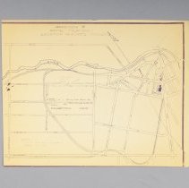
Title |
Map, Royal Tour, Location of School Children, 1959 |
Date |
1959 |
Year Range from |
1959 |
Year Range to |
1959 |
Description |
Map of the location of school children during the Royal Tour of Guelph, dated to 1959. This map depicts where each school was lined up along the tour route. The Collegiate and Junior classes from all schools were standing along Woolwich between Wyndham and Norfolk. The Notre Dame and Loretto schools were standing along Norfolk, between Woolwich and London Road. The McCrae, Tytler and St. George Public Schools stood along London Road. The Scouts, Cubs, Guides, and rural students were along Exhibition Street. The students of St. Joseph's, St. John's, and St. Stanislaus were along Division Street. The King George, Ottawa Crescent, Laurine, Paisley Road, Torrance, Sacred Heart, Holy Rosary, Central and King Edward Schools, and disabled students from all schools, were along Woolwich Street, between Division Street and London Road. Titled as "Appendix C Royal Tour 1959 Location of School Children." |
Notes |
Mapmaking is an ancient, global, and subjective practice. Maps can help us to understand land relationships over time. It is important to understand why a specific map was made, whose interests it reflected, and how it was intended to be used. These understandings are shaped by knowledge of the land from diverse perspectives, past, present, and future. Historical Context: Early Indigenous navigational maps of the place we now call Canada were drawn on impermanent materials, accompanied by verbal descriptions and committed to memory. Landmarks were accentuated to aid travellers and scale was often measured by time (such as, a day's journey). In about 1502, European mapmakers depicted the east coast of Newfoundland as an island in the North Atlantic. World maps skewed the size and shape of continents and used colour to symbolize colonial powers. The first surveyors measured and marked plots of land - taken, traded, granted, or sold - often naming the landholders on the map. Today, the science and practice of mapmaking documents the topography of the landscape in fine detail, through aerial photography, sensors, satellites, and global positioning/information systems (GPS/GIS). |
Search Terms |
Canadian National Railway Station Carden Street Centennial Collegiate and Vocational Institute Central School City Hall Division Street Exhibition Park Exhibition Street Grand Trunk Railway Station Guelph Collegiate Vocational Institute (GCVI) Holy Rosary School King Edward School King George School Laurine Avenue Public School Loretto Academy McCrae (John) Public School Notre Dame High School Ottawa Crescent School Paisley Road School Royal Visits Sacred Heart School St. George's School St. George's Square St. John's School St. Joseph's School St. Stanislaus School Torrance Public School Tytler Public School Woolwich Street Wyndham Street |
Subjects |
EDUCATION EDUCATION - PRIMARY EDUCATION - SCHOOLS EDUCATION - SECONDARY SPECIAL EVENTS - ROYALTY |
Collection |
Archives |