Archives Record
Images
Metadata
Catalog Number |
1980.75.2 |
Object Name |
Survey, Land |
Title |
Land Survey, Mitchell Street and Eramosa Road, Francis Kerr, 1852 |
Date |
1852 |
Year Range from |
1852 |
Year Range to |
1852 |
Description |
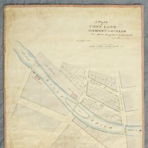
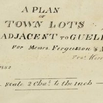
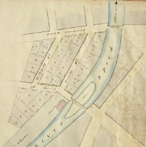
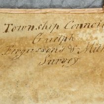
Survey of the land along Mitchell Street and Eramosa Road, published by Francis Kerr in 1852. The survey depicts grey-coloured lots bounded by the Speed River, Bridge Street (Norwich Street), Mitchell Street and Eramosa Road, and includes lot measurements, and streets. The Speed River is in blue, and pink rectangles indicate grist mills, saw mills and a new foundry. The map is printed on paper with a fabric backing and is bordered with a fading pink ribbon. The survey is titled "A plan of Town Lots Adjacent to Guelph for Messrs. Fergusson & Mitchell, 1852. Francis Kerr, P.L.S." The back of the map bears the original title: "Township Council Guelph, Fergusson's and Mitchell's Survey, 1852." |
Notes |
Mapmaking is an ancient, global, and subjective practice. Maps can help us to understand land relationships over time. It is important to understand why a specific map was made, whose interests it reflected, and how it was intended to be used. These understandings are shaped by knowledge of the land from diverse perspectives, past, present, and future. Historical Context: Early Indigenous navigational maps of the place we now call Canada were drawn on impermanent materials, accompanied by verbal descriptions and committed to memory. Landmarks were accentuated to aid travellers and scale was often measured by time (such as, a day's journey). In about 1502, European mapmakers depicted the east coast of Newfoundland as an island in the North Atlantic. World maps skewed the size and shape of continents and used colour to symbolize colonial powers. The first surveyors measured and marked plots of land - taken, traded, granted, or sold - often naming the landholders on the map. Today, the science and practice of mapmaking documents the topography of the landscape in fine detail, through aerial photography, sensors, satellites, and global positioning/information systems (GPS/GIS). |
People |
Clarke, (Dr.) Clarke, William (Dr.) Fergusson, Adam Johnston (A.J.) Fergusson, William Kerr, Francis Mitchell, John Mitchell, Robert |
Search Terms |
Arthur Street Bridge Street Eramosa Bridge Eramosa Road Fergusson's Mill London Road Norwich Street Norwich Street Bridge Perth Street Speed River |
Subjects |
COMMERCIAL - MILLS MAPS MILLS |
Collection |
Archives |