Archives Record
Images
Additional Images [9]
Metadata
Catalog Number |
2013.39.29.15 |
Object Name |
Map |
Title |
Maps, Zoning By-Law, 1952 -1953 |
Year Range from |
1952 |
Year Range to |
1953 |
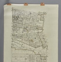
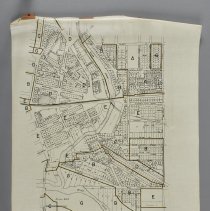
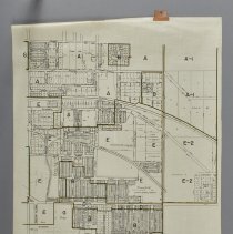
Description |
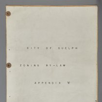
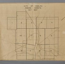
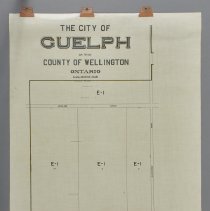
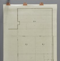
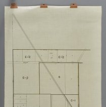
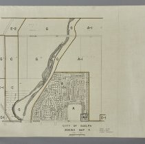
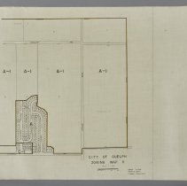
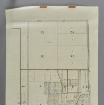
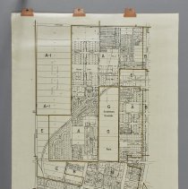
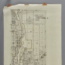
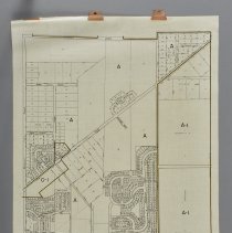
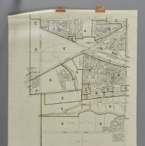
Zoning and detail maps made for the City of Guelph Planning Commission, by Gordon Culham Dryden and Smith Planning Consultants, dated between 1952 and 1953. .1 - Booklet titled, "City of Guelph, Zoning By-Law, Appendix "A," composed of 16 pages. Front and back covers are made of blueprint paper. The booklet is bound with three brass tacks which make it difficult to fully-open the pages. Produced by Gordon Culham Dryden and Smith Planning Consultants. On the reverse of the back cover of the booklet is "City Clerk's Office, City of Guelph," hand-written in pencil. .2 - The page is titled as, "City of Guelph, Zoning Sheets, Key Map," and is identical to the first page in the booklet. It is made of paper and has 3 cello clips along one edge and is badly torn at each clip. There is tape at these tears as well. .3 - The page is titled as, "The City of Guelph in the County of Wellington Ontario," and is identical to the second page of the booklet. It is made of plastic-coated linen and has 3 cello clips along one edge. .4 - The page is titled as, "City of Guelph Zoning Map 2," and is identical to the third page of the booklet. It is made of plastic-coated linen and has 3 cello clips along one edge. .5 - The page is titled as, "City of Guelph Zoning Map 3," and is identical to the fourth page of the booklet. It is made of plastic-coated linen and has 3 cello clips along one edge. .6 - The page is titled as, "City of Guelph Zoning Map 4," and is identical to the fifth page of the booklet. It is made of plastic-coated linen and has 3 cello clips along one edge. .7 - The page is titled as, "City of Guelph Zoning Map 5," and is identical to the sixth page of the booklet. It is made of plastic-coated linen and has 3 cello clips along one edge. .8 - The page is titled as, "City of Guelph Zoning Map 6," and is identical to the seventh page of the booklet. It is made of plastic-coated linen and has 3 cello clips along one edge. .9 - The page is titled as, "City of Guelph Zoning Map 7," and is identical to the eighth page of the booklet. It features Exhibition Park. It is made of plastic-coated linen and has 3 cello clips along one edge. .10 - The page is titled as, "City of Guelph Zoning Map 8," and is identical to the ninth page of the booklet. It is made of plastic-coated linen and has 3 cello clips along one edge. .11 - The page is titled as, "City of Guelph Zoning Map 9," and is identical to the tenth page of the booklet. It is made of plastic-coated linen and has 3 cello clips along one edge. .12 - The page is titled as, "City of Guelph Zoning Map 10," and is identical to the eleventh page of the booklet. It is made of plastic-coated linen and has 3 cello clips along one edge. .13 - The page is titled as, "City of Guelph Zoning Map 11," and is identical to the twelfth page of the booklet. It is made of plastic-coated linen and has 3 cello clips along one edge. .14 - The page is titled as, "City of Guelph Zoning Map 12," and is identical to the thirteenth page of the booklet. It is made of plastic-coated linen and has 3 cello clips along one edge. .15 - The page is titled as, "City of Guelph Zoning Map 13," and is identical to the fourteenth page of the booklet. It features the International Malleable Iron Company, and Guelph Stove Works. It is made of plastic-coated linen and has 3 cello clips along one edge. |
Notes |
Mapmaking is an ancient, global, and subjective practice. Maps can help us to understand land relationships over time. It is important to understand why a specific map was made, whose interests it reflected, and how it was intended to be used. These understandings are shaped by knowledge of the land from diverse perspectives, past, present, and future. Historical Context: Early Indigenous navigational maps of the place we now call Canada were drawn on impermanent materials, accompanied by verbal descriptions and committed to memory. Landmarks were accentuated to aid travellers and scale was often measured by time (such as, a day's journey). In about 1502, European mapmakers depicted the east coast of Newfoundland as an island in the North Atlantic. World maps skewed the size and shape of continents and used colour to symbolize colonial powers. The first surveyors measured and marked plots of land - taken, traded, granted, or sold - often naming the landholders on the map. Today, the science and practice of mapmaking documents the topography of the landscape in fine detail, through aerial photography, sensors, satellites, and global positioning/information systems (GPS/GIS). |
Search Terms |
Albert Street Alexander (John) Furniture Warehouse Alexander Street Alexandra Street Allan Avenue Alma Street Ardmay Crescent Argyle Street Armstrong Avenue Arnold Street Arthur Street Audrey Avenue Augusta Street Avondale Avenue Bagot Street Baker Street Barber Avenue Barton Street Bay Street Bedford Street Bellevue Street Bennett Avenue Beresford Road Birmingham Street Breadalbane Street Brockville Avenue Brunswick Avenue Cadillac Drive Calgary Avenue Cambridge Street Campion Avenue Cannon Street Cardigan Street Cardigan Street Cassino Avenue Cavell Avenue Cedar Street Central Road Chase Avenue Chester Street City of Guelph City of Guelph - Department of Planning and Development Clara Street Clarence Street Clarke Street Clinton Street Clive Avenue Collingwood Cork Street Crimea Street Daly Crescent Dawson Road Delhi Street Derry Street Division Street Division Street Dodds Avenue Donnell Avenue Dormie Lane Douglas Street Drew Avenue Dufferin Street Dumbarton Street Dunkirk Avenue Earl Street Edinburgh Road Edmonton Drive Elora Road Emma Street Eramosa Road Erie Street Essex Street Exhibition Park Exhibition Street Extra Street Fairview Boulevard Farquhar Street Fergus Street Forbes Avenue Forest Drive Forest Hill Drive Franchetto Boulevard Frank Cote Drive Frederick Street Galt Street Garabaldi Street Garth Street George Street Gladstone Avenue Glasgow Street Glengary Street Glenmill Place Glenwood Avenue Goldie Street Gordon Culham Dryden and Smith Planning Consultants Gordon Street Gowdy Avenue Green Street Guelph Stove Company Guelph Street Hamel Avenue Harris Street Harrison Avenue Hatch Street Havelock Street Hayes Avenue Hearn Avenue Heffernan Street Hepburn Avenue Home Street Hood Street Hooper Street Hospital Street Industrial Street Inkerman Street International Malleable Iron Company Jackson Street James Street Jessie Street John Street Johnston Street Kathleen Street Kensington Street Kerr Street King Street Kingsmill Avenue Kirkland Street Kitchener Street Knightswood Boulevard Lane Street Laurine Avenue Lawrence Avenue Lemon Street Liverpool Street London Road Lucan Street Lyon Avenue Mac Avenue Manor Park Crescent Maple Street Martin Avenue Mary Street McCall Crescent McCrae Boulevard McTague Street Meadowview Avenue Melville Street Memorial Crescent Menzie Avenue Mercer Street Merion Street Merrit Boulevard Metcalfe Street Mill Street Minnie Street Mitchell Street Mont Street Morris Street Mount Street Naborhood Shoe Store Napoleon Street Neeve Street Nelson Road Norfolk Street North Street Nottingham Street Oakwood Avenue Omar Street Orchard Crescent Ottawa Crescent Oxford Street Paisley Road Palmer Street Palmer Street Park Avenue Parkholme Avenue Paul Street Perth Street Peter Avenue Philip Avenue Pipe Street Powell Street Quebec Street Queen Street Raglan Street Regina Avenue Renfield Street Richard Street Ridgewood Avenue Robinson Avenue Roland Street Rosewood Avenue Shaftesbury Avenue Shirley Avenue Silvercreek Parkway Simcoe Street Skov Crescent Sleeman Avenue Smith Avenue Southhampton Street Speedvale Avenue Spring Street St. Andrews Street St. Catharine Street St. George's Square Stanley Street Stevenson Street Stevenson Street Strange Street Stull Avenue Suburban Avenue Suffolk Street Sultan Street Summit Crescent Sydenham Street Thomas Street Thorp Street Tiffany Street Tipperary Place Torrance Crescent Vancouver Drive Vardon Drive Verney Street Verney Street Vernon Street Victoria Road Walter Street Water Street Water Street Waterloo Avenue Webster Street Wellington Boulevard Wells Street Western Avenue Wheeler Street William Street William Street Wilson Street Winston Crescent Wolfond Crescent Wolseley Road Woodlawn Road Woodycrest Drive Woolwich Street Wyndham Street Yarmouth Street York Road Ypres Street |
Subjects |
ARCHITECTURE GOVERNMENT - MUNICIPAL GOVERNMENT - MUNICIPAL - PLANNING |
Dimensions |
93 cm w x 78.5 cm l |
Collection |
Archives |